Dungeons & Dragons 5e Campaign needs an Overland View Map
¿Quieres ganar un trabajo como este?
Este cliente recibió 6 diseños de ilustración de 5 diseñadores. Eligieron este diseño con ilustración de Filip Paul como el diseño ganador.
Únete gratis Encuentra trabajos de diseño- Garantía
-
 US$330
-
 6 diseños
-
 5 diseñadores
Resumen de Diseño Con Ilustración
SUMMARY
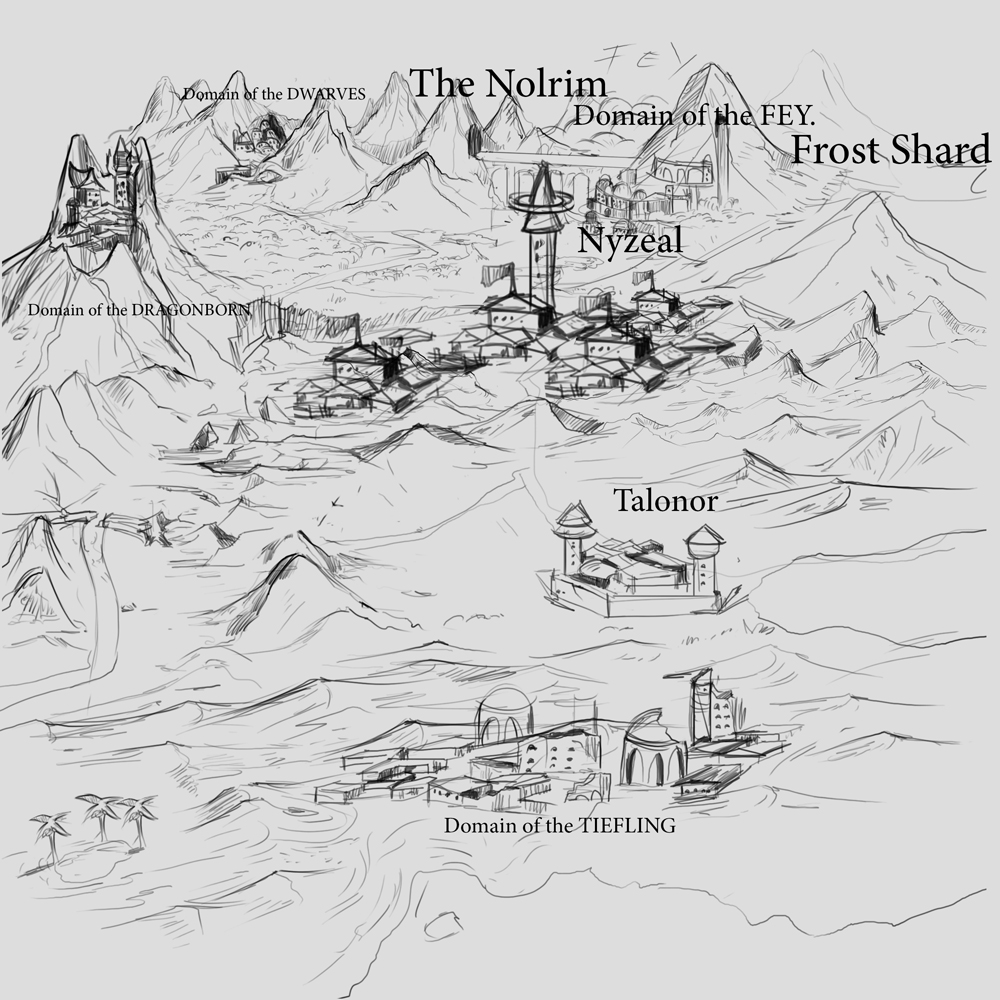
The project is for a world map/atlas that shows the major areas in an upcoming Dungeons & Dragons campaign. This project is for a private campaign this not for the purpose of marketing or selling. We would like the final product to be a High Resolution original graphic file from which we can print a professional quality poster – size map to use in our campaign.
The map itself needs to include several conceptual main areas which can be labeled on the map. We would also like the original design files (.psd or ai, etc..) so that we can go back in and add additional areas as our campaign progresses. We would also like a conceptual artwork on the map that represents cities, ruins, villages and towns
As far as the style goes, I have included a map of "Stormhollow" which is where we have drawn alot of our inspiration. This map is just an example and not part of the map we are asking you to design. Therefore, we are not necessarily looking for our finished project to be a copy of any of the included examples, these are provided just as a point of reference.
NEEDED STYLIZED AREAS
NORTHERN GLACIER AREA (Frost Shard)
- This is a frozen tundra/glacier with mountains
COASTAL AREA(S)
• There is no particular place of interest to highlight here; just that the coast meets the water, etc.
LARGE MOUNTAINOUS AREA(s)
• Several mountain ranges spattered all throughout the map with the largest being more north and called “The Nolrim”.
3 THE FIVE DOMINIONS
1st Dominion: Domain of the FEY.
• Their dominion sits in the wilds below a mountain range with Water Falls, etc. (Think Lord of the Rings)
2nd Dominion: Domain of the DWARVES
They have found their refuge within the Nolrim and exist mostly isolated from the rest of the Dominions; rarely venturing outside of the heart of the mountain - Nolrim.
3rd Dominion: Domain of the DRAGONBORN
Their dominion centers on a large volcano. The area surrounding is all hardened magma. Very little vegetation, etc.
4th Dominion: Domain of the TIEFLING
The Tiefling Empire is now known as the Forsaken Lands a southern desert waste land that stretches for hundreds of miles... The old capital of Varsu’ul lay in ruin. Almost in the middle of this desert is the second largest library in the world known as the Desert Libram.
5th Dominion: Domain of the HUMANS
The fifth dominion split into a northern and southern empire.
Northern contains the large capital called Nyzeal, the City of Sorcery.
• Partly due to its strategic travel routes to the other four dominions and partly because of its openness to all races, the Humans of Nyzeal created the vast city of Nyzeal.
• As a political and dominion agnostic city, Nyzeal has historically been the location where each of the King’s Table meetings have been convened and where the next is designated to occur.
• Nyzeal is the center piece of the story and should be pretty prominent on the map.
Southern contains the capital city of Talonor, more toward the coast.
Stormhollow Map
Again, this map is just to show you what was inspiring some of the land mass ideas that we wish to be included on the map. We would love a 3d version such as the Stormhollow Map entails; however, the style of map can be up to the discretion of the artist.
Please ignore all of the titles of places on the included map.
Thank you for looking at our project!
Updates
Project Deadline Extended
Reason: Increased the project budget. As a beginner to these types of things, it was not my intention to undervalue the work of any artists.
Added Friday, January 09, 2015
Objetivo del mercado(s)
This is an overland map for an adventure that we are writing for a role playing game. As such, it needs to be pretty visually stimulating.
Tipo de industria / entidad
Marketing
Requisitos
Debes tener
- Must have the key locations mentioned above. There is some discretion to the designer about how to organize these locations on the map. We thought of the desert area being southern on the map and